 Urban Area Change Detection using SAR data
|
Provides:
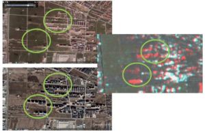
Red color indicates the areas where changes occurred between the two time moments. Blue circles represent different types of changes characterizing the urban areas. |
Makes use of: Sentinel 1 IW (Interferometric Wide) GRDH (Ground Range Detected, High Resolution), Google Earth Maps, Open Street Map and Google Maps Smart features:
|
Read more: https://smurbs.eu/deliverables/
Developers: 
Contact Information: Ioana Vlad ([email protected])
SMURBS cities: Bucharest (Romania)