Portfolio solutions and projects

<< GO BACK  

  MINOAN: 2D/3D MappINg Of urbAn iNfrastructure

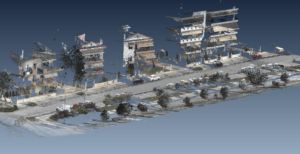
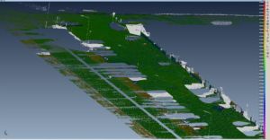
Provides:

– Mapping of urban infrastructure (roads, ring roads, bridges, tunnels) status
– Mapping of building facades and trees adjacent to roads
– Mapping of highways and exit roads status
– Support decision making of local / regional authorities during and immediately after disaster (floods, fires, extreme winds with MMS and UAV swarms)
– Support disaster preparedness via mapping of critical urban infrastructure and disaster scenario simulation
– Industrial infrastructure for accidents pre- and post- assessment


    Change detection and monitoring of a small neighborhood in Thessaloniki


Makes use of: Satellites, MMS, GNSS, UAVs


Smart features:

– Near real time information during disasters
– Web GIS for information dissemination
– Synergy of a wide variety of EO platforms


Read more: https://smurbs.eu/deliverables/

Developers:     

Contact Information: Petros Patias ([email protected])

SMURBS cities: Thessaloniki (Greece)


Involved Partner(s): AUTH (GR)
EO Platform(s) utilized:  IoT  Satellites
Theme: theme-icon Disasters