
 FloodHUB: Flood monitoring service
|
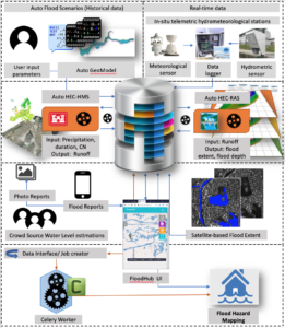
Provides: – Urban and peri-urban NRT flood monitoring using multi-source EO, in-situ and crowdsourced data (via the dedicated FloodHub platform) – Flood scenarios in alignment with the relevant EU Floods Directive – Support decision making of local/regional authorities, ministries, and agencies such as civil protection authorities, NGOs, insurance agencies etc. – Flood risk management plan
|
Makes use of: In-situ monitoring, crowdsourced data
via the dedicated Floodhub platform, Sentinel-1 & 2 satellites (https://sentinels.space.noa.gr/) or other VHR satellite data and tailor-made hydrological and hydraulic models (HEC).
Smart features: – Automatic assimilation of flood modeling in Real Time integrating multi-source EO, in-situ and crowd data – Continuous validation and optimization of results – On line free and open access to all the available flood products: NRT flood map, flood scenarios (historical data), post-disaster analysis maps – Near Real Time information during the disaster delivering a continuous awareness picture contributing to flood monitoring and management – User friendly web and mobile application – Computational efficiency, flexibility, scalability, transferability |
Read more: https://floodhub.beyond-eocenter.eu/floodHub
Developers: ![]()

Contact Information: Haris Kontoes ([email protected])
SMURBS cities: Athens (Greece)