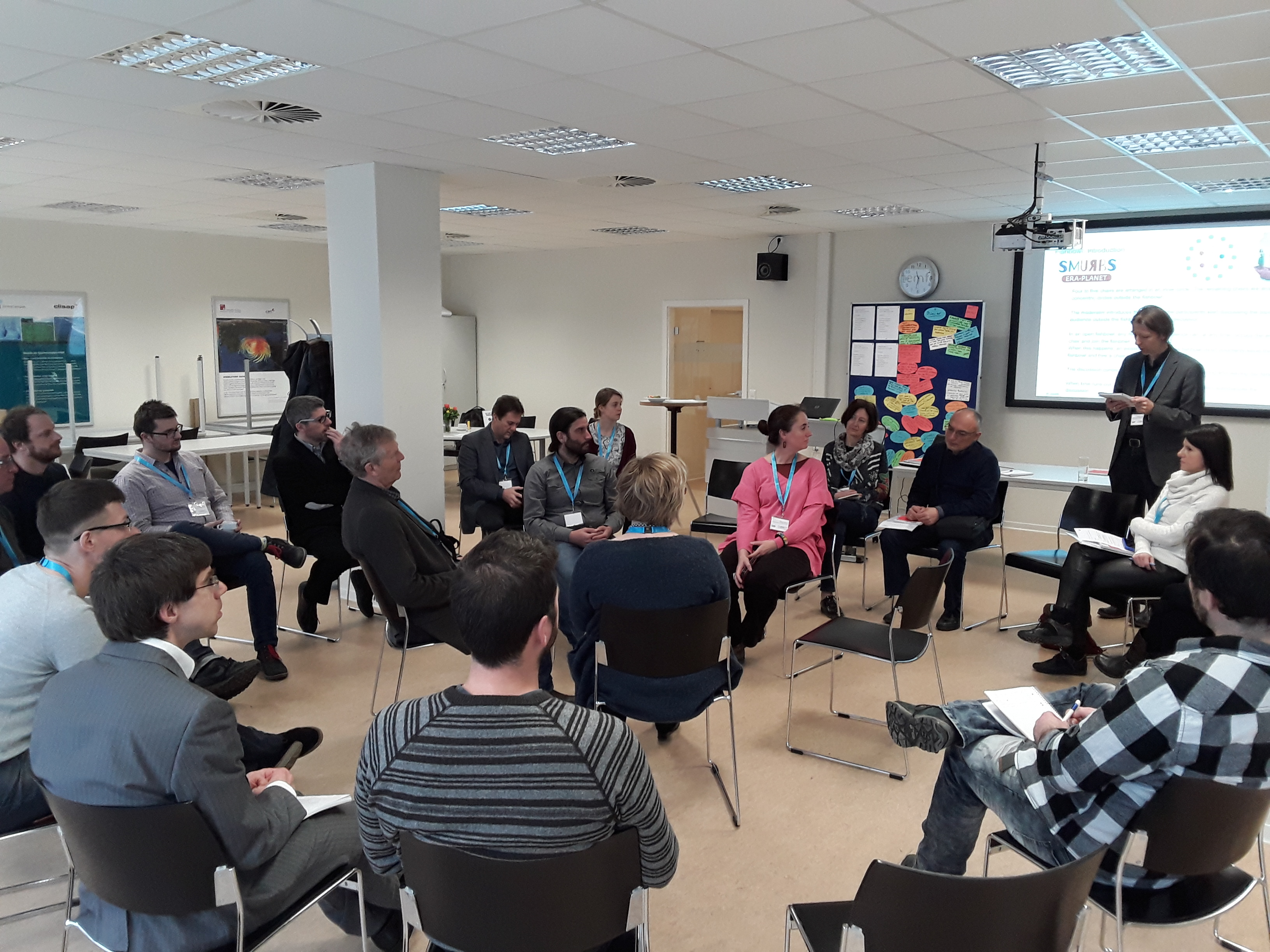
SMURBS successfully organized the 1st Stakeholders’ workshop on User Needs, held in Hamburg Germany, 27-28 March 2018
This workshop was central for the purposes of WP2 on User Needs and the preparation of D2.1 and was thus organized early on. Twenty five stakeholders from ten European cities, with affiliations ranging from public administration to the academia, gathered in Hamburg, on late March 2018 for a two-day workshop on user needs, towards the strategic planning of the design, implementation and delivery of the portfolio of Smart Urban Solutions of SMURBS, in the months ahead and up till the end of the project.
Smartphones and laptops were switched off, as the workshop focused heavily on the face-to-face interaction between the stakeholders and adopted the communication method of “World Café” table discussions per SMURBS theme, and of a plenary “fishbowl” discussion, where all participants had the opportunity to stir and enrich the conversation.
These communication tools were selected based of positive past experience and because they allowed for a quick and efficient method to establish and decompose the User Needs framework upon which SMURBS constructed its following activities of WP2. Moreover, the keynote talk given by Prof. Dr. Matthias Augustin (University Medical Center Hamburg‐Eppendorf) in the subject of “Urban health from a medical perspective: Data – Needs – Gaps” delivered a critical overview of a generalized concept of Urban Health and provided a common ground for the distinct -per theme- discussions and some thematical targets to be addressed by the workshop’s outcomes.
The workshop’s outcome will critically complement the other user-needs gathering activities of SMURBS (online survey, interviews). Some results were expected, and some were enlightening. Overall, the hierarchy of the needs that took place, and the local dependence of some, surfaced through the discussions, will surely help SMURBS to create more efficient and targeted solutions. Last but not least, this workshop provided a first-class opportunity for engagement of public authorities and partners alike, for a very down-to-earth implementation of solutions for the rest of the project’s life.

These separate tables were organized based on the three main themes of SMURBS, while stakeholders could participate in more than one discussion, based on their competence and overall interest. The theme tables had the same horizontal questions, to which the participants had to provide their particular answers and they are summarized as follows:
The AQ table focused on the importance of small-scale emitters like residential wood combustion and vehicle emissions that are strongly interconnected to behavioral patterns and social aspects, as they are governed by actions of individuals, thus, a solution should extend to both citizens and policy makers. Still, regional and/or trans-boundary transport of pollution can reduce the impact of local policy measures. The table also identified specific pollutants of particular concern including ultrafine particulate matter (PM1), NO2, black carbon (BC), and O3 with respect to their regulatory status and degree of incorporation of current scientific knowledge on their impacts on health. Finally, the urban hyper-localization of AQ issues was punctuated, and discussion on the adequateness of traditional single-point or urban background monitoring stations to describe urban micro-environments ensued, that may introduce disconnects to exposure and health impacts’ estimation.
Two general characteristics surfaced at UG table, that of the locality of the problem, i.e. dependence on city or country and, secondly, the strong interconnection of the urban growth theme with the other SMURBS’ themes (especially AQ and Disasters). More particular issues that surfaced included illegal structures/change of land use (LU) especially if post-fire situations or due to land grazing, loss of green areas/soil sealing, an issue high in the EU agenda, with strong connection to floods and urban microclimate and, lastly, unregulated waste disposal hot-spots with its underlying strong “NIMBY” (not in my backyard) aspect. Moreover, the table discussed the, different across EU countries, patterns of urban expansion, i.e. densification, urban sprawl, polycentric, which are partly governed by socio-economic factors and share common impacts (e.g. urban heat island) as well as particular to the pattern impacts such as overall quality of life (densification) and energy expenditure (sprawl).
The Disaster table identified floods, peri-urban fires, earthquakes, landslides and industrial accidents with toxic releases as the main city issues, which are unambiguously interconnected with the other SMURBS’ themes. Additionally, critical factors that can increase the impact of a disaster event were discussed, like land cover changes and arbitrary human interventions in disaster prone areas, urban sprawl or densification that does not take into account estimated disaster risks, limited awareness and training, especially for the citizens or authorities in high risk areas and lack or inadequacy of mitigation measures, e.g. absence or insufficiency of technical works, emergency pathways, evacuation plans.
The AQ table underlined the importance of concurrently delivering the EO data in suitable format both to the decision maker and the individual citizen to trigger a respective action. Among policymakers, a general enthusiasm deficit for the integration of EO data in the decision-making process was noted owing to the lack of personnel/resources and inaccessibility or unsuitability of data. Non-local sources and jurisdiction overlap among agencies further hinders responsibility assignment and efficient policy making. Lack of knowledge regarding one’s personal risk relating to air quality and lack of education regarding the effect of one’s actions on air quality as well as existing knowledge gaps in causative relationships between air quality and health outcomes undermine motivation and decisiveness for citizens and policy makers alike. Finally, Although AQ measurements with high spatial and temporal density are highly desirable, EO approaches such as low-cost smart sensors are still a long way from providing data of satisfactory quality.
In a similar manner, the UG discussion overwhelmingly revolved around the weakness of public authorities to make meaningful use of Earth Observation (EO) data and added that easy linkages for tailor-made services to the authorities is the way forward, i.e. facilitation of access and straightforward tailored information with comprehensible indicators. A more established, permanent and dedicated “EO department/structure” within urban administration was agreed upon as the best option to foster EO integration. A second challenge identified was the capacity of EO to really support “city standards” criteria. This, should be pursued through criteria co-creation (including urban metrics) with city planners, monitoring and active facilitation of policy enforcement. Lastly, the taking into account the strong socio-economic interconnection of the majority of the issues, argued on the necessity for effective integration of EO data with socio-economic data, in order to provide effective but also socially equitable decision making.
The Disasters table also identified issues in the lacking of data integration and coordination among the relevant authorities. Data management and capacity building was discussed as the way to overcome this (in cloud manner to safeguard against power outages at the crucial moment), in the form of comprehensive operational systems, an open reference point for all authorities, feeding and receiving information for the different phases of the disaster cycle, allowing for local legal particularities (e.g. false alarms vs no alarms) and assuring necessary resources for training. Reliable pre- and post- disaster information about the risk and extent of the disasters, respectively, are of paramount importance both for the civil protection authorities. Therefore, a challenge lies in the uncertainty of collected data, especially when crowd-sourced, and of the provided information. Artificial intelligence, machine learning, data mining and statistical analysis techniques were discussed in the light of improving the overall quality of information.
Finally, and this was acknowledged at all tables, lack of continuity for services and applications (because of lack of funding after a project’s end) is a critical obstacle and strong deterrent for actual EO integration in urban decision making. Similarly, with respect to Disasters, lack of interest after the event is only too frequent. The need for awareness raising on the consequences of the disaster and the importance and benefits of mitigation measures was unanimously put forth.
To bridge the distance between the policy makers and the novel capacities offered by EO, the AQ table suggested building of a knowledge base is needed in the form of an online database of good practices in air quality management and a database of air quality-related laws and rules for EU countries. The educational gap of the citizenry could be bridged through two strategies. EO integration with smartphone technology is one of them, entailing personalized information on high resolution AQ and measures to act accordingly. The second strategy involves general/real-time communication of air quality status using existing media infrastructure, analogous to existing communication of weather bulletins. The importance of utilizing communication methods appropriate for age and socioeconomic conditions was noted.
The UG table took closely into account the previous discussions and main points made, and the solutions that were registered were closely linked to each problem while remaining challenge-aware. Thus, the discussion revolved around development of indicator(s) regarding proximity of work/life to capture the commute aspect of what constitutes a city, indicator(s) to quantify densification/urban sprawl to offer quantifiable arguments in the urban policy making, correlation of Urban Heat Island and LU classification satellite imagery to enable scenario-analysis, integration of crowd-sourced imagery with satellite data to improve LU information and boost awareness, integration of soil sealing products and flood related indicators recognizing the correlation between the two and, finally, integration of satellite LU products and socio-economic data to develop highly potential illegal building maps in post-fire situations.
The Disasters discussion revolved around the aspect of integration of crowd-sourced data into Copernicus Emergency Management Service – Mapping activation (Rapid Mapping and Risk & Recovery) that would add value to these services. Moreover, big data analytics could foster historical combined analysis of various data-series of crucial parameters relevant to a disaster, and this long-term knowledge could lead to the creation of alerting indicators for the disaster at hand.
The AQ table identified several obstacles running through the entire discussion. An overriding obstacle is the difficulty in establishing tangible links between air quality and adverse health or societal outcomes that are readily apparent to both policy-makers and the general citizenry. This contributes to reluctance among policy-makers for legislation at local, national, or trans-national scales, as well as a lack of incentive for the individual to incorporate air quality considerations into their daily lives. The incorporation of EO data into the smart city paradigm, combined with its efficient up-take and dissemination, is viewed as an effective method for overcoming these tendencies. As local and personal aspects of the envisioned solutions require low-cost sensors and air quality modeling to be part of the smart city solution, overcoming existing citizen and policy-maker skepticism regarding smart sensor quality and reliability is of major importance. Transparent, documented, and readily accessible validation of both sensor and model outputs is likewise deemed critical.
The UG discussion quickly focused on ways to overcome the challenge of public authorities to use Earth Observation (EO) data for urban growth aspects. All stakeholders agreed that smart city methods could help in achieving this and the way forward is to openly and smartly disseminate the gathered information to policy makers and citizens alike. One stop-shop solutions were suggested, such as a unified web-portal or smartphone app(s) that will gradually create a reference point for all parties to have an overview on urban growth issues for their city. Easy to grasp indicators (such as the ones discussed above) should populate these platforms, along with scenarios analysis for future urban growth and mitigation measures. Strong showcasing of benefits was deemed necessary and, finally, the EO capacity for delivering objective state-of-the city perspective, bypassing national versus local authorities shortcomings (e.g. the NIMBY aspect) was acknowledged as one of the key advantages that should shape the EO-policy interface.
The First Round of the fishbowl revolved around EO data fragmentation and structural challenges in its effective use and dissemination by stakeholders. The ever increasing amount of data from various platforms is overwhelming according to the stakeholders’ opinion and cannot be efficiently used in everyday decision making. The offered services to the authorities should ensure handling, filtering and analysis of data in the back office and deliver straightforward information. Structural challenges exist in providing long-term sustainability of procured data and offered services according to the stakeholders from the academia. This, was agreed upon, could be partly alleviated by private initiative (e.g. spin-off companies) and largely by the DIAS (Copernicus Data and Information Access Services) that was created for this purpose.
The Second Round of the fishbowl addressed the issue of crowdsourced data and discussed its potential as an EO source that can complement existing ones, and also the main obstacles for successful implementation. The discussion was initially driven by particular city crowdsourcing projects, their shortcomings and benefits they brought forward. Scientific robustness is the foremost concern as quality assurance is difficult to achieve, the amount of data can become overwhelming and unwieldy, thus transforming the problem into a statistical challenge. Some stakeholders claimed that scientific robustness may receive second billing, in cases where crowdsourced data is used for model calibration and not as primary source of information. In the same manner, such data can help in pattern recognition (not absolute values). The above, either way, include the positive aspect of increase of awareness and participatory motivation for citizens. Another major concern that surfaced in this round is low citizen participation or decline of engagement. The solutions put forth included gamification and achievement based awarding, financial incentives (direct or indirect), “dedicated crowdsourcing” by already invested individuals like public servants in relevant bodies (e.g. firemen), notwithstanding aspects of data ownership and sensitivity. Lastly, perception of impact was agreed upon as the most imperative aspect any crowdsourced method/project must address. A separate discussion ensued on the public authorities reluctance to actively involve citizens in data gathering. Public authorities, in order to avoid misinterpretation of data (independently from this data being robust or not) by the public and possible alarm or panic, are many times reluctant to utilize or even endorse crowdsourcing. Unanimously, it was decided that SMURBS should help bridge this gap, avoiding confrontation and sensitizing authorities to the benefits citizen participation brings, in short, complementarity of data and engaged/active citizens. Furthermore, since the participation through smart methods trend seems growing and ultimately inevitable, the fishbowl concluded that is more wise to embrace and foster such initiatives, offering however the much needed, scientific guidance.
In the Third and final round, the stakeholders stepped into the shoes of ordinary citizens and discussed what the ideal situation would be in terms of offered information and the means of receiving it. The key points that surfaced were: Personalised/tailored information, according to a citizen’s health profile, favored over more generalised output (e.g. city map). Localised information was the second “citizen” requirement registered. This entails offering the citizen information closely related to his/hers daily activities. Direct provision of information was agreed upon as the optimum method for assuring the information is delivered and actually registered by the user. The fishbowl discussion continued with a more society as whole perspective and firstly addressed the issue of limits and recommendations as set by public authorities. Different protocols that apply in different countries were registered, banning was juxtaposed to recommendation and some legal perspectives were discussed for actually enforcing a banning of activities on citizens or private companies (e.g. fire place/car usage). Regarding concerns of the public to divulge personal data, clear delineation of the data routes and storage was proposed as well as the use of static sensors. Finally, with a view more focused on SMURBS, some of the participants cautioned against providing too much information or creating various apps in an environment quickly becoming saturated. Instead, SMURBS should focus on robust science, keeping it under the hood, and delivering a few impactful solutions to the public.